Circumnavigating Cape Island
William G. McArthur
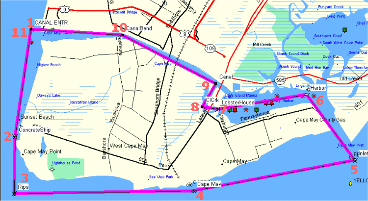
Paddling a kayak around the island at the bottom of Cape May peninsula is an interesting trip and a relatively easy one if you plan properly. Sea conditions should be calm to moderate because of two possible rough spots on the trip. I like to leave from my beach which is 3 miles north of the Cape May Canal, but this trip starts at the public beach at Douglass Park in Town Bank. My round trip is 22 miles whereas this trip totals 15.8 miles. All distances in this description are in statute miles (as opposed to nautical miles).WGM 02/08/2002 (revised 04/30/2008)The key to planning this paddle is to launch at about 2 hours before low tide at the mouth of Cape May Inlet. The ebb tide will carry you around Cape May Point and up the beach to the inlet. You want to enter the inlet at slack tide so that the current is negligible. Once the flood tide begins, water moves west up the Cape May Harbor and out the Cape May Canal. The plan is to take a detour past the Lobster House and under the small bridge into Cape May, to Cape Island Creek, and then up the Cape May Canal to the Delaware Bay again.
I've broken the route down into numbered waypoints, shown on the map above:
Waypoint 1: N38.96842 W74.96355 (Douglass Memorial Park)
The first leg begins at the public beach at Douglass Memorial Park. To get to the parking area, first drive to the intersection of Lincoln Boulevard and Beach Drive in Town Bank. From the entrance to the park, drive south down Beach Drive approximately 1/2 mile to the parking lot. There are porta-potties in the lot for your convenience. The launch place is on the beach to the west of the parking lot. Paddle along the north canal jetty to the entrance of the Cape May Canal (Waypoint 11) and head south down the bay. Be very careful of boat traffic coming in and going out of the canal. You also have to watch for fishing lines from those fishing the canal jetties. Just south of the canal is Higbee Beach. It is 1.9 miles to the concrete ship Atlantus, in front of Sunset Beach. You can (and should) paddle through the middle of the shipwreck. You can land at Sunset Beach if you need a break or to shorten the paddle. There are several gift shops and an awesome display of photography at the top of the beach.Waypoint 2: N38.94173 W74.97173 (Concrete Ship)You have a good chance of spotting dolphins near the concrete ship during the warm months of the year. I have also seen Wilson's Storm Petrels and a Pilot Whale in this area. There are a series of jetties (actually, groins) around the curve of Cape May Point. The jetty ends are quite visible near low tide, but beware if you paddle around near high tide because the jetty ends can be submerged. The best course is to paddle about 20 yards off of the jetty ends. The standing waves of the rips usually don't occur in close. I've put in an arbitrary waypoint 1 mile from the concrete ship, but the best bet is just to follow the jetty ends.Waypoint 3: N38.92756 W74.97194 (Arbitrary - rips)The Cape May rips are famous for standing waves, hydraulics, and striper fishing. As you paddle around the point, you will see the "convent", which is actually a retreat house for nuns. This imposing structure, precariously perched on the rocks used to be 500' inland. Next, you pass the Cape May Lighthouse, located in Cape May Point State Park. Just down the beach is a WWII concrete bunker which used to be 700' inland. The beach which runs from the bunker to the Cape May fishing jetty is 1.2 miles long. You can paddle just outside the breakers for a while, but be cautious as you approach the fishing jetty; there are lots of shoals in the area on the west side of the jetty. You should give the fishing jetty a wide berth. I have put in another arbitrary waypoint just off of Howard Street in Cape May, 3.1 miles from the rips. As you pass this area, you will see the mural on the back of Convention Hall by artist David Dunleavy.Waypoint 4: N38.92828 W74.91486 (Arbitrary - Cape May beachfront)As you paddle past this waypoint, you will see the Sea Mist Apartments standing out from the other buildings. This beautiful red and white structure is painted yearly and is a lovely landmark. This leg of 2.8 miles is the only one that puts you on some open water. The west jetty on the Cape May Inlet juts far out from the beach on U.S. Coast Guard property. Try to shoot right toward the next waypoint at the entrance to the inlet. You will see two yellow buoys to your right. During rifle practice at the Coast Guard base, these buoys mark a safe course out of gunfire range. If you hear gunfire, you might want to paddle outside of these buoys. I've never heard of anyone being hit by bullets going by here.Waypoint 5: N38.93580 W74.86354 (Cape May Inlet entrance)If all has gone according to plan, it should be around slack low tide as you enter the inlet. This is a very busy waterway in the warm months, so stay alert. The best course is to stay near to the west (left) jetty, but not so near as to be in danger of being washed into the rocks by wake. The inlet is naturally deep, but as you approach the Cape May Harbor, there is a shoal on the left which can have breaking waves from boat wakes. As you paddle down the inlet, you will see the "fifty cent bridge" on Ocean Drive straight ahead. This leg into the inlet is 1.4 miles. Instead of going to the next waypoint, you should turn left into the harbor staying fairly close to land on the left.Waypoint 6: N38.95214 W74.87878 (Cape May Harbor)As the flood tide begins, water will move west up the harbor. The land area to the left is the Coast Guard Base until you come to the Corinthian Yacht Club. Just past the yacht club, there is a memorial to lost fishermen looking over the harbor. You will paddle through a fleet of moored sailboats from all over the world. This leg is 1.5 miles to the Lobster House Restaurant. The little cove to the left is called "Devil's Reach". You will see the Schooner America (third edition) anchored at the Lobster House on your right.Waypoint 7: N38.94852 W74.90705 (Lobster House)South Jersey Marina is just past the Lobster House. There are some huge boats in this area so stay alert. You will paddle under a small bridge that carries the bulk of traffic into Cape May from the Garden State Parkway. This leg is just 0.3 miles to Cape Island Creek where you will turn right.Waypoint 8: N38.94911 W74.91217 (Cape Island Creek)As you turn right, the Miss Chris Marina is on the right. There is a salt marsh on the left which provides some good birding at times. There is plenty of boat traffic on the creek, but it is all slow-moving. Work your way to the left side of the creek. This leg is 0.5 miles long and is the only part against the flood current.Waypoint 9: N38.95488 W74.90779 (Cape May Canal)As you turn left into the canal, you will again have the current at your back. Stay to the left side of the canal, but not too close to the shallow edge because of breaking boat wakes. There are lots of boats and lots of boat wakes in the canal. On your right is the Tranquility development. Be especially wary around the railroad trestle. The current runs very swiftly here and boat wakes can confuse the water. I always go through the left side, under the overhanging cable. Boats are not supposed to go through there, so it is much safer. Just on the other side of the trestle is the West Cape May bridge. Once again, stay to the left. This leg runs 1.8 miles to the bend in the canal near a cable crossing.Waypoint 10: N38.96688 W74.93754 (Canal Bend)As you paddle past the canal bend, you will see the Cape May/Lewes Ferry complex ahead on the right. I try to cross over to the right side of the canal just before the ferry slips and just after the no wake zone begins. Watch out for ferries! You don't want to be between a ferry and the side of the canal. Be patient! As you paddle up along the north canal jetty, watch for boat wakes and fishing lines. I always try to sprint along this stretch. This leg is 1.6 miles to the entrance to the canal.Waypoint 11: N38.96833 W74.96667 (Canal Entrance)Turn right just past the canal entrance and head back to where you launched on the north side of the jetty.