Paddle Across the Delaware Bay 2007
William G. McArthur
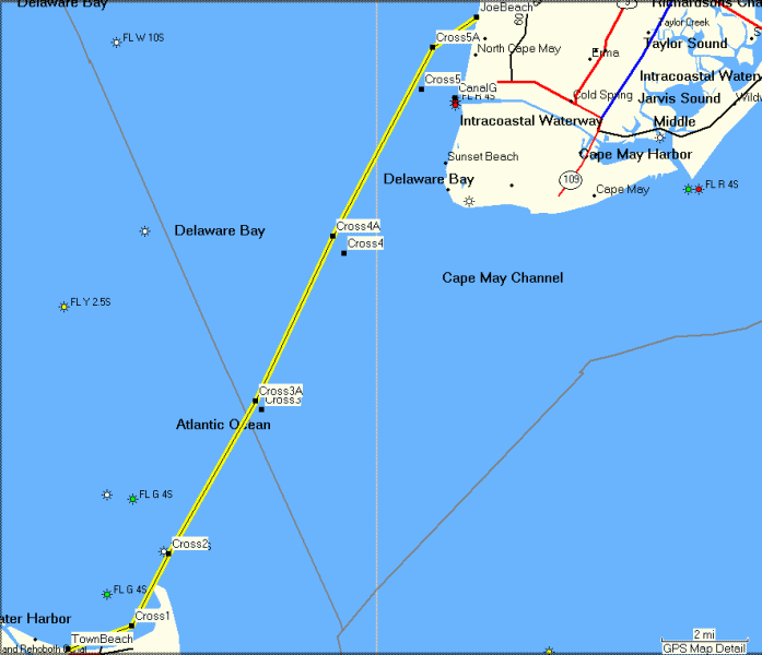
This year's bay crossing is scheduled for August 18. We are launching from the Lewes town beach promptly at 9:00 AM. The trip ends at the public beach at Pinewood Road beach in Town Bank at around 1:30 PM after a paddle of 18 miles. All distances in this description are in statute miles (as opposed to nautical miles).Slack water at low tide is predicted for 8:00 AM at Breakwater Harbor, so we will have a favorable current for the entire paddle if we cross in a timely manner. The maximum velocity of the current is predicted at 1.2 knots on a bearing of 339° magnetic at 11:11 AM. We will essentially be following the ferry route across the bay. To this end, we begin by paddling south to go between the breakwater and Cape Henlopen. We will try very hard to stay clear of shipping heading to or from Philadelphia or other northern points. Saturday is a day of lighter traffic in the shipping channel, but some ships do travel on Saturday. We need to be very alert from the outer breakwater to waypoint CROSS4A for large ships.
I've broken the route (click here for raw data) down into labeled waypoints, shown on the map above:
Waypoint TownBeach: N38.78224 W75.13356 (Lewes Town Beach)
The first leg is 1.6 miles to the end of the inner breakwater. The current should be light and to our backs. Our bearing is 82 ° magnetic. The course should be line-of sight to the south end of the inner breakwater.Waypoint CROSS1: N38.78987 W75.10622 (South End of Inner Breakwater)The next leg is 1.9 miles to the next waypoint. The bearing is 39° magnetic. The course should be line-of sight to the south end of the outer breakwater. We need to watch for large ships.Waypoint CROSS2: N38.81416 W75.09035 (South End of Outer Breakwater)The next leg is 4.1 miles to the next waypoint. Our navigation bearing is 45° magnetic, but we will be subject to current drift. We need to watch for large ships.Waypoint CROSS3A: N38.86567 W75.05260The next leg is 4.2 miles to the next waypoint. The bearing is 45° magnetic, but we will be subject to current drift. We need to watch for large ships.Waypoint CROSS4A: N38.92132 W75.01934The next leg is 5 miles to the next waypoint. The bearing is 45° magnetic, but we will be subject to current drift.Waypoint CROSS5A: N38.98477 W74.97633The next leg is 1.3 miles to the next waypoint. The bearing is 68°. We need to watch for jet-skis.Waypoint JoeBeach: N38.99503 W74.95716 (Beach at Pinewood Road)It's Miller time!
WGM 08/03/2007