Paddle Across the Delaware Bay 2003
William G. McArthur
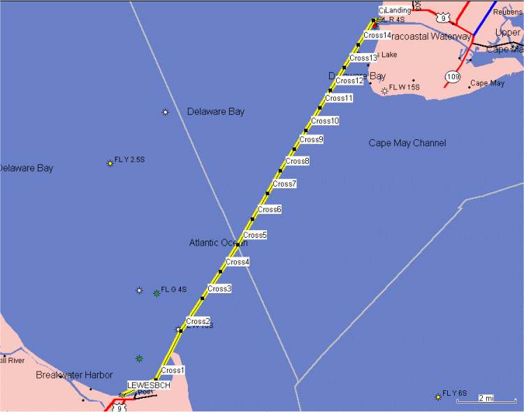
This year's bay crossing is scheduled for July 20. We are launching from the Lewes town beach promptly at 9:30 AM. The trip ends at the public beach at Douglass Memorial Park in Town Bank at around 2:00 PM after a paddle of 15.9 miles. All distances in this description are in statute miles (as opposed to nautical miles).Low tide is predicted for 7:20 AM at Breakwater Harbor, so we will have a favorable current for the entire paddle if we cross in a timely manner. The maximum velocity of the current is predicted at 1.0 mph on a bearing of 339° magnetic. We will essentially be following the ferry route across the bay. To this end, we begin by paddling south to go between the breakwater and Cape Henlopen. We will try very hard to stay clear of shipping heading to or from Philadelphia or other northern points. Sunday is the day of lightest traffic in the shipping channel, but some ships do travel on Sunday. We need to be very alert from the outer breakwater to waypoint CROSS6 for large ships.
I've broken the route down into labeled waypoints, shown on the map above:
Waypoint LEWESBCH: N38.78236 W75.12787 (Lewes Town Beach)
The first leg is 1.3 miles to the end of the inner breakwater. The current should be light and to our backs. Our bearing is 78° magnetic. The course should be line-of sight to the south end of the inner breakwater.Waypoint CROSS1: N38.78987 W75.10622 (South End of Inner Breakwater)The next leg is 1.9 miles to the next waypoint. The bearing is 39° magnetic. The course should be line-of sight to the south end of the outer breakwater. We need to watch for large ships.Waypoint CROSS2: N38.81416 W75.09035 (South End of Outer Breakwater)The next leg is 1.3 miles to the next waypoint. The bearing is 46° magnetic. We need to watch for large ships.Waypoint CROSS3: N38.83028 W75.07644The next leg is 1.1 miles to the next waypoint. The bearing is 45° magnetic. We need to watch for large ships.Waypoint CROSS4: N38.84372 W75.06530The next leg is 1.1 miles to the next waypoint. The bearing is 46° magnetic. We need to watch for large ships.Waypoint CROSS5: N38.85682 W75.05415The next leg is 1.0 miles to the next waypoint. The bearing is 42° magnetic. We need to watch for large ships.Waypoint CROSS6: N38.86975 W75.04469The next leg is 1.0 miles to the next waypoint. The bearing is 43° magnetic.Waypoint CROSS7: N38.88232 W75.03521The next leg is 0.9 miles to the next waypoint. The bearing is 42° magnetic.Waypoint CROSS8: N38.89360 W75.02686The next leg is 0.9 miles to the next waypoint. The bearing is 45° magnetic.Waypoint CROSS9: N38.90444 W75.01794The next leg is 0.7 miles to the next waypoint. The bearing is 44° magnetic.Waypoint CROSS10: N38.91355 W75.01070The next leg is 0.9 miles to the next waypoint. The bearing is 44° magnetic.Waypoint CROSS11: N38.92483 W75.00179The next leg is 0.7 miles to the next waypoint. The bearing is 43° magnetic.Waypoint CROSS12: N38.93350 W74.99510The next leg is 0.9 miles to the next waypoint. The bearing is 44° magnetic.Waypoint CROSS13: N38.94478 W74.98619The next leg is 0.9 miles to the next waypoint. The bearing is 44° magnetic.Waypoint CROSS14: N38.95605 W74.97727The next leg is 1.0 miles to the next waypoint. The bearing is 45° magnetic.Waypoint CROSS15: N38.96820 W74.96737The next leg is 0.2 miles to the next waypoint. The bearing is 98° magnetic.Waypoint LANDING: N38.96841 W74.96352It's Miller time!
WGM 06/25/2003