Paddle Across the Delaware Bay 2001
William G. McArthur, July 27, 2001
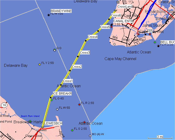
This year's bay crossing is scheduled for August 26. We are launching from the Lewes town beach promptly at 9:00 AM. The trip ends at the public beach at Pinewood Road and Shore Drive in Town Bank at around 1:00 PM after a paddle of 17.7 miles. All distances in this description are in statute miles (as opposed to nautical miles).Low tide is predicted for 9:06 AM at Breakwater Harbor, so we will have a favorable current for the entire paddle. The maximum velocity of the current is predicted at 1.4 mph on a bearing of 339° magnetic. One of the keys to the trip is to stay north and west of the ferry route. To this end, we begin by paddling to the north end of the icebreakers since the ferries pass either near the south end of the icebreakers or the south end of the breakwater. Another key is to try to stay clear of shipping heading to or from Philadelphia or other northern points. Sunday is the day of lightest traffic in the shipping channel, but some ships do travel on Sunday. We need to be very alert from the icebreakers to waypoint CROSS2 for large ships.
I've broken the route down into labeled waypoints, shown on the map above:
Waypoint LEWESBCH: N38.78236 W75.12787 (Lewes Town Beach)
The first leg is 3.9 miles to the icebreakers. The current should be very light, so a magnetic bearing of 28° should get us there in about an hour. We want to stay north of the icebreakers to stay away from the ferries.Waypoint ICE BREAKR: N38.83667 W75.10833 (Icebreakers)The next leg is 2.0 miles to the next waypoint. The bearing is 51° magnetic, but since the current will tend to move us north of our target, our bearing should be about 55°.Waypoint CROSS1: N38.85941 W75.08473 (About 1/2 hour)The next leg is 2.1 miles to the next waypoint. The bearing is 45° magnetic, but since the current will tend to move us north of our target, our bearing should be about 50°.Waypoint CROSS2: N38.88543 W75.06356 (About 1/2 hour)The next leg is 2.0 miles to the next waypoint. The bearing is 42° magnetic, but since the current will tend to move us north of our target, our bearing should be about 48°.Waypoint CROSS3: N38.91096 W75.04481 (About 1/2 hour)The next leg is 2.2 miles to the next waypoint. The bearing is 39° magnetic, but since the current will tend to move us north of our target, our bearing should be about 45°.Waypoint CROSS4: N38.93958 W75.02642 (About 1/2 hour)The next leg is 2.0 miles to the next waypoint. The bearing is 64° magnetic, but since the current will tend to move us north of our target, our bearing should be about 70°.Waypoint CROSS5: N38.95736 W74.99742 (About 1/2 hour)The next leg is 2.0 miles to the next waypoint. The bearing is 55° magnetic, but since the current will tend to move us north of our target, our bearing should be about 60°.Waypoint CROSS6: N38.97861 W74.97177 (About 1/2 hour)The next leg is 1.4 miles to the landfall. The bearing is 48° magnetic, but since the current will tend to move us north of our target, our bearing should be about 52°.